Magmasid, mag-ulat, at maging LIGTAS!
The geographical location of the Philippines and the continuous effect of climate change makes the country vulnerable to various extreme weather events that result to disasters that include landslides or mass wasting that affect the environment and could result in loss of lives and properties.
Based on the data from the Philippine Atmospheric, Geophysical and Astronomical Services Administration (PAGASA), the Philippines experiences an average of twenty typhoons per year that bring approximately 4,000 millimeters of rain. The excessive rainfall often leads to fatal disasters, particularly slope failures or landslides.
Studying the geophysical characteristics of landslides is as significant as determining economic and socio-cultural impacts of landslides in communities, especially in high-risk mountainous areas. Additionally, studying the landslide characteristics, behavior, and areas susceptible to occurrence and recurrences is of importance.
Deriving rainfall-landslide thresholds
Over the years, records of damages and casualties have led to government initiatives to mitigate landslides and its corresponding effects.
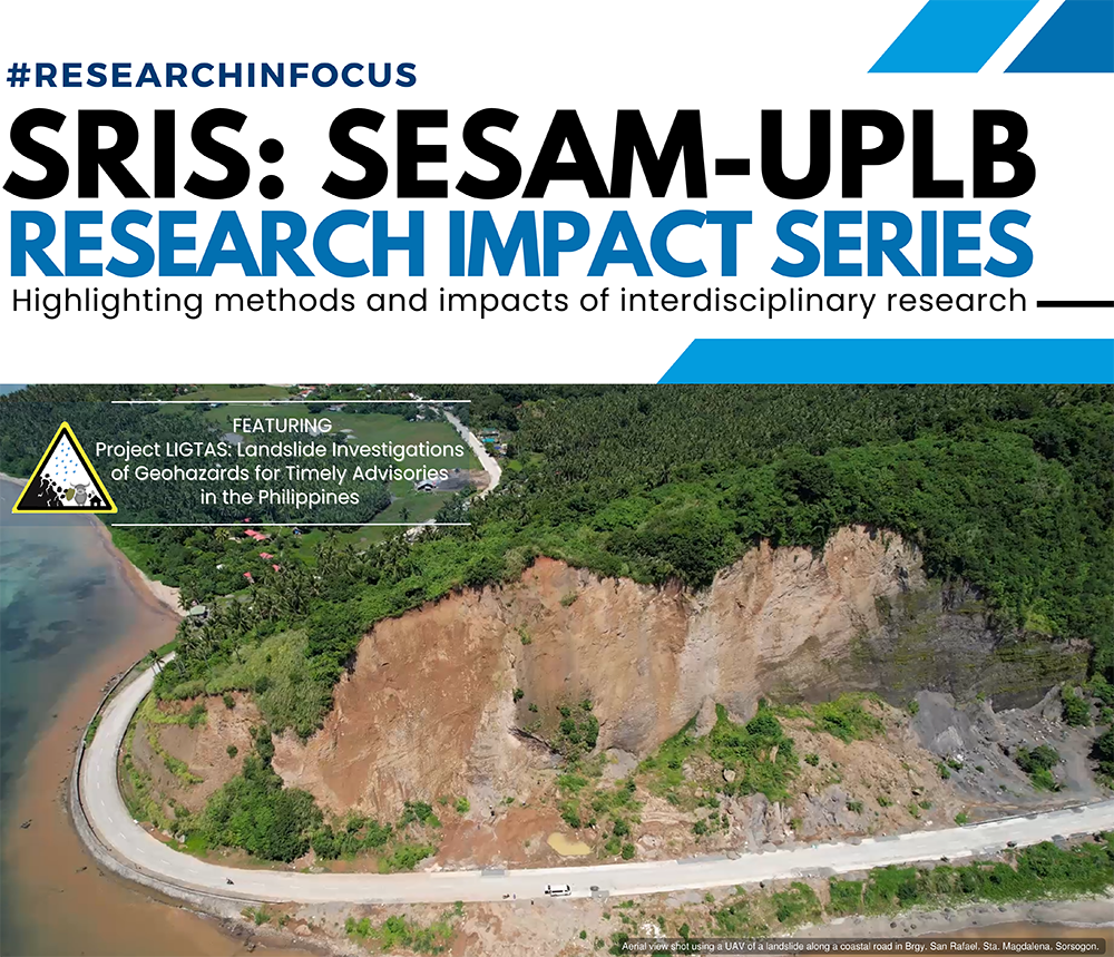
Project LIGTAS or Landslide Investigations on Geohazards for Timely Advisories in the Philippines is being funded by the Department of Science and Technology (DOST), to improve our understanding of shallow landslides and formulate early warning systems for the country.
“We wanted to develop mitigation measures to save lives. And so, we crafted a project that can answer the following questions: When would landslides likely occur? How much rain is needed to trigger landslides?”
Project LIGTAS focuses on the generation of a non-structural preventive measure for landslide disasters using rainfall-landslide thresholds. This semi-quantitative approach estimates the minimum rainfall amount and duration that can trigger landslides in a specific area by applying a power-law model to corresponding accumulated rainfall events and recorded dates of landslide occurrences. With more data, these statistics can only get better.
From 2021-2023, research is focused on mineralized areas of Benguet, and the volcanic terranes of Southern Tagalog and Bicol Regions. The rainfall data being used by Project LIGTAS are from the DOST – Philippine Atmospheric, Geophysical and Astronomical Services Administration (PAGASA), the Advanced Science and Technology Institute (ASTI), the Climate Hazards Group InfraRed Precipitation (CHIRPS) was used as an alternative, and AWS units installed by the project.
With the current data, results show that 27 mm of rainfall already starts to trigger slope failures in the Southern Tagalog region, while landslides in the selected areas in the Bicol region are triggered at around 90 mm of rainfall. Lower thresholds were generated for the Benguet province wherein slope failures start at 12mm of rainfall.
Use of Automatic Weather Stations for a Real-time rainfall monitoring System
Despite the increasing number of weather monitoring stations that have been deployed in the country, many remote sites are still not covered by surface observations. Thus, there is a need to improve the availability of weather data for improving weather monitoring and strengthening resilience to the impacts of adverse weather conditions.
Project LIGTAS installed a total of ten (10) AWS units in different sites in Luzon and Visayas. The team deployed a total of six (6) AWS units in the Province of Benguet. All installation works were completed in partnership and coordination with the Local Government Units (LGUs) of Benguet. In partnership with the Batangas State University – Lobo Campus, one (1) AWS unit was also installed in the Municipality of Lobo, Batangas. Another set of an AWS unit was also installed in Catarman, Northern Samar in partnership with the University of Eastern Philippines (UEP). One unit of AWS is at the UPLB Laguna-Quezon Land Grant and another unit is at the National Arts Center in Mt. Makiling. The latest installation was done in Catanauan, Quezon in partnership with Manuel S. Enverga University Foundation.
Aside from these project-installed AWS, LIGTAS also utilizes weather data generated by other weather monitoring stations from its partners such as Project SARAi or the Smarter Approaches to Reinvigorate Agriculture as an Industry in the Philippines and DOST-ASTI.
Into the new normal: citizen science for LIGTAS rainfall-landslide monitoring research
In order to generate a site-specific rainfall-landslide threshold, landslide event data such as exact location, date and time, and amount of rainfall that trigger the landslide are needed. However, lack of these information is a challenge. Since data is very limited and at times publicly unavailable, Project LIGTAS collects landslide events data from various platforms, such as household surveys, on-the-ground validation works, online data mining, and citizen science reports.
The project’s goal is to improve the accessibility of localized weather data for the use of Local Government Units and other stakeholders in the region. And to achieve this goal, a portal was created. This portal is being used by the project as a crowdsourcing platform to store landslide events from the reports of the community as a form of citizen science.
“People contributing to the science of landslide studies.”
LIGTAS Portal as a national landslide database
Project LIGTAS answers the challenge of lack of information for site-specific weather data, historical landslides and early warning systems that can affect emergency preparedness and disaster response of the community through a Portal through the easy accessibility of localized weather data and early warning systems for the use of LGUs.
The LIGTAS Portal (ligtas.uplb.edu.ph), which is accessible to everyone with an internet connection, is useful for landslide reporting and provides access to landslide information and advisories. Landslide reports are stored in the database including landslide data summary such as coordinates to locate them on a map. Aside from this, data from fieldwork activities and secondary data from official reports are being utilized. The collected data are converted to a vector layer to make an interactive web map using the Application Programming Interface (API) of ArcGIS online. Additionally, the landslide early warning system features an interactive map showing the location of the reported landslide events and the location of the Automatic Weather Stations (AWS) installed by the project and other partner organizations. Using ArcGIS online, the landslide early warning system also features color-coded advisories based on the collected rainfall data from the AWS units.
These features of the LIGTAS portal can serve as a decision-support tool of local government units in making necessary actions for disaster preparedness including evacuation activities. Furthermore, everyone can use this for free, which can therefore support communities in planning for disaster mitigation and early warning systems ensuring that no one is left behind in preparing for impacts against disaster risks.
Tayo ay magkaisa bilang isang citizen science community sa pamamagitan ng pagrereport ng mga pagguho sa inyong lugar.
Mag-report ng pagguho sa LIGTAS Portal (www.ligtas.uplb.edu.ph) at sama-sama nating buuin ang National Landslide Database!
Magmasid, mag-ulat, at maging LIGTAS, Pinas!Project LIGTAS is a three-year research project funded by the DOST – Philippine Council for Industry, Energy and Emerging Technology Research and Development (PCIEERD) under the Manila Economic and Cultural Office (MECO) – Taipei Economic and Cultural Office’s (TECO) call for Volcanoes, Oceans, Typhoons, and Earthquake (VOTE) collaborative researches. (Rosemarie Laila Areglado)